


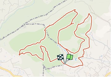
Le tour Bois St Jaume et le Camp Romain

Renefrt
User


2h58
Difficulty : Medium

FREE GPS app for hiking
 SityTrail
IGN / Geographical institutes
SityTrail Plus
The world is yours!
About
Trail Walking of 9.4 km to be discovered at Provence-Alpes-Côte d'Azur, Maritime Alps, Le Rouret. This trail is proposed by Renefrt.
Description
Très belle randonnée forestière en boucle, à travers les bruyères, les pins et les massifs de cistes, qui contourne les bois du Rouret et de Saint-Jaume. Les crêtes de la cote 463 à la cote 465 vous offrent des vues Sud sur le littoral, et Nord vers les Gorges du Loup. La grotte de la Baume Robert clôturera cette très agréable balade.
Se garer sur le parking du Chemin du Castellet. Puis direction balise 295
Positioning
Comments